Sollipulli Volcano Hike Guide: Epic Glacier & Volcano Experience in Chile
- Nov 19, 2025
- 6 min read
Updated: Dec 12, 2025
The Sollipulli Volcano hike in Chile's Araucania region offers one of South America's most unique landscapes.
There are sometimes hikes that make you feel small and open your eyes to the wonder of mother nature. This is one of them. The Sollipulli Volcano Hike takes you to a juxtaposition of nature, a glacier (ice) inside a Volcanic Crater (fire), and not just any crater, the largest in South America stretching 4km wide.

For reasons we do not know, Sollipulli hasn't been put on the tourist trail, meaning you’ll likely have this hike all to yourself (we only found it through word of mouth…) This has to be one of the last hidden gems of Araucania.
This guide on the Sollipulli Volcano Hike will share everything you need to know about climbing the 2,282m, although a warning here: if you hike this trail in October like us, be prepared for deep snow and a hard slog. If you attempt this hike in Winter then you'll need specialist equipment such as crampons and perhaps even a guide to follow the route.
📍 Location: Araucania Region, Chile
⏱️ Duration: 5.5-6.5 hours
📏 Distance: 14km round trip
📈 Elevation Gain: 1,200m
💪 Difficulty: Hard
💰 Cost: Free
🗓️ Best Time: November-April
How To Get To Sollipulli Volcano: Directions & Access
Sollipulli Volcano is in the Araucania region of Chile, near the Argentinian border. The hike is best accessed with your own car (4x4 is helpful, but not necessary, our friends made it with their 2WD), but there are also guided tours that use a mini bus.
We came from Parque Nacional Congullio (another place not to miss) along the S-61, where you turn off and start the climb in your car up a narrow rocky road to the entrance.
There is a small, free parking lot at the base of the hike near the rangers hut. When we hiked there was only one other car here and one other group on the trail, this is a real hidden gem of Chile's hiking.
You can hike the volcano from the north face or the south face, but it is only possible to cross the glacier with a guide due to deep crevasse. If you choose to hire a guide and complete the crossing you can spend a night near or on the glacier to break up the long trek.
We choose to hike the north face from Melipeuco, a more well trodden path and the way we outline in our blog below.

How Much Is The Sollipulli Hike?
You need to register with the ranger at the base with either your RUT or Passport Number and then you're good to go.
The hike is completely free, plus there are toilets at the base (this is great if you live in a car like us without a toilet!)
There is also a sign here, advising that you don’t start the hike after 11am (although we don’t know if this is enforced.)
Sollipulli Hike Difficulty: How Long Does It Take?
The whole hike took us 6 1/2 hours (ascent 4 hours, descent 2 hours), although if we hiked in summer we would knock off an hour due to deep snow, sometimes up to our knees, that we had to navigate in order to get to the summit.
AllTrails classifies this as a hard hike and we have to agree, you need a good level of fitness and a large supply of snacks!
What To Expect From The Sollipulli Hike
For us, this is one of the best hikes we've ever done (and comparable to the hiking in Norway)!
The trail starts off with a steep climb through thick forest where you can hear the rumble of a waterfall and chirping of birds.
You will reach the first Mirador, a view over the surrounding forests, but don't stop here for too long as the views just keep getting better all the way to the top.
As we emerged out of the forest we hit the snowline (late October) and this is where it started to get tricky. Navigating through the melting snow meant some deep pits where we'd just fall through.
We followed the orange poles and arrows (slightly different to the AllTrails route) that lead you to stunning vistas of the Andes mountain range and views of Llaima volcano.
From here you’ll climb up to a collection of trees before turning left and cutting across under the volcano. A steep section will bring you up to the trail along the ridge line!

Just before the top we reached an arm of the glacier that we needed to cross, this looked slightly dodgy with an overhanging shelf and if you head on the hike it might be best to check with the ranger the safety of the route.
We tried to reroute but found ourselves but exposed on a mountain peak we quickly retraced our steps and headed along the original route, hugging the side least likely to get hit by an avalanche.


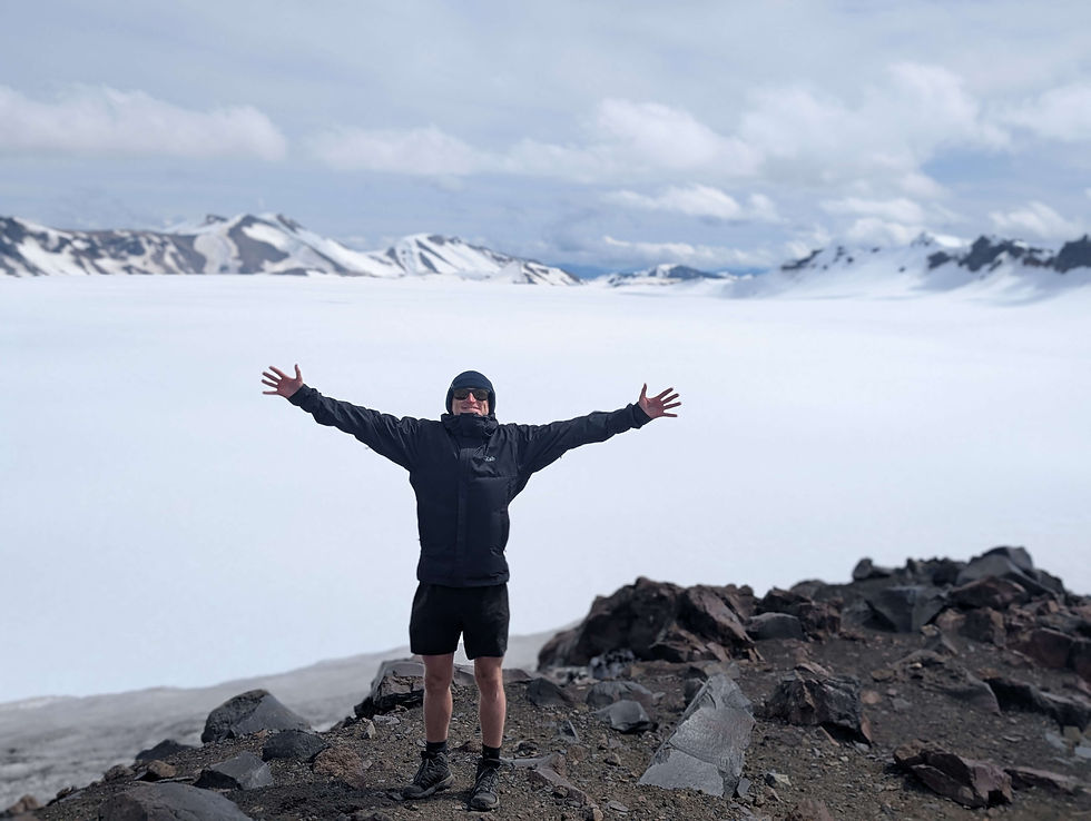
With clenched bum holes we reached the summit, a reward worth the exhaustion. The glacier stretches to the edges of the carter, a white sea contained by sharp, rugged peaks.
This was unlike anything we had seen before and we're unsure if we will see anything like it again!

About The Sollipulli Glacier
A mammoth 2.5 miles long and 640m thick you won’t be disappointed by the summit view over Sollipulli which was created more than a thousand years ago. The contrasting black volcanic rock against the brilliant white glacial ice is astounding and one reason why this hike is so memorable.


Tips For the Sollipulli Hike
The best time to hike Sollipulli is from November to May when the snow has melted. We trekked in October and still had lots of snow, making the path hard but not impossible.
Take your sticks! This climb is steep and mainly on volcanic scree or snow. The last section to the summit where you see the glacier is extremely steep and we were glad we had our hiking poles.
Be prepared for the wind! The path is exposed so pack warm clothing for the last section of the climb.
If you’re in a camper or an overlander you can no longer stay at the start of the hike overnight. Instead we recommend retracing your tracks down the hill a little and staying in this wild camp spot.
Sollipulli Hike FAQs
Do I need a guide for Sollipulli Volcano?
No, you can hike the north face independently. However, crossing the glacier requires a licensed guide due to dangerous crevasses.
Is Sollipulli Volcano active?
Sollipulli is considered active but dormant and hasn't erupted since 1240AD .
How hard is the Sollipulli hike?
Only experienced hikers with good fitness should attempt this trail. The steep terrain, high altitude, and changing weather make it a tricky hike.
Is there cell phone service?
No, there's no cell service on the trail. Download offline maps. We used this AllTrails path.
How long does the Sollipulli hike take?
The Sollipulli volcano hike takes 5.5-6.5 hours round trip, depending on conditions.
Have you hiked Sollipulli Volcano? Share your experience in the comments below to help other hikers like you!

Don't Forget To Pack
 | Good Hiking Gear Chile has a diverse landscape, from the desert to the mountains. One thing we were glad to have were our sticks, whether it was for scree, snow or sand they helped a lot with hiking.
|
 | LifeStraw Filtered Water Bottle Allowing you to fill up water whenever and wherever with peace of mind plus you’re helping the environment! |
 | JetBoil For multi-day hikes, bikepacking and campers we highly reccomend a JetBoil. Get boiling water in under a minute. This made our life so much easier! |
 | Leatherman We would recommend this to anyone who is living in a camper. It’s heavy duty so not light for hiking but it has been our go-to for everything from quick repairs in the car. |
Top Tips For Travelling Chile
Travel by Campervan - This is the best way to explore Chile's diverse landscapes! For longer trips, check out Suzi CTW - a brilliant concept where you buy a campervan, do your journey, then sell it to another traveller.
Pack for All Weather Conditions - Chile's climate varies dramatically from the Atacama Desert to Patagonian winds. Invest in quality layered clothing and waterproof gear.
Seek Out Off-the-Beaten-Path Destinations - While Torres del Paine and San Pedro de Atacama are stunning, don't overlook lesser-known gems like the Lakes District's hidden villages, Chiloé's mystical islands, or the Conguillo National Park.
Embrace the Adventure - Chileans are warm and welcoming people who love sharing their country's beauty. Don't be afraid to ask for recommendations or chat with locals - you'll discover the best picadas (local eateries) and secret spots that no guidebook mentions!
Travel Tools To Help You Plan
These are some of the travel tools we love and use daily, by booking through our links you support our blog and help us grow, thank you.
Thank you for reading and enjoy your Chilean adventure. Reach out to us over on Instagram @KateandMikesTravels. We always love to hear from people who read our blogs!


.png)

Comments